Scientific Regions
The following regions, used in the scientific literature, are available in regionmask:
Giorgi Regions (from Giorgi and Franciso, 2000)
SREX Regions (Special Report on Managing the Risks of Extreme Events and Disasters to Advance Climate Change Adaptation (SREX) from Seneviratne et al., 2012)
AR6 Regions (Iturbide et al., 2020; ESSD)
PRUDENCE Regions (from European Regional Climate Modelling PRUDENCE Project, Christensen and Christensen, 2007)
The following imports are necessary for the examples.
In [1]: import regionmask

In [2]: import cartopy.crs as ccrs
Giorgi Regions
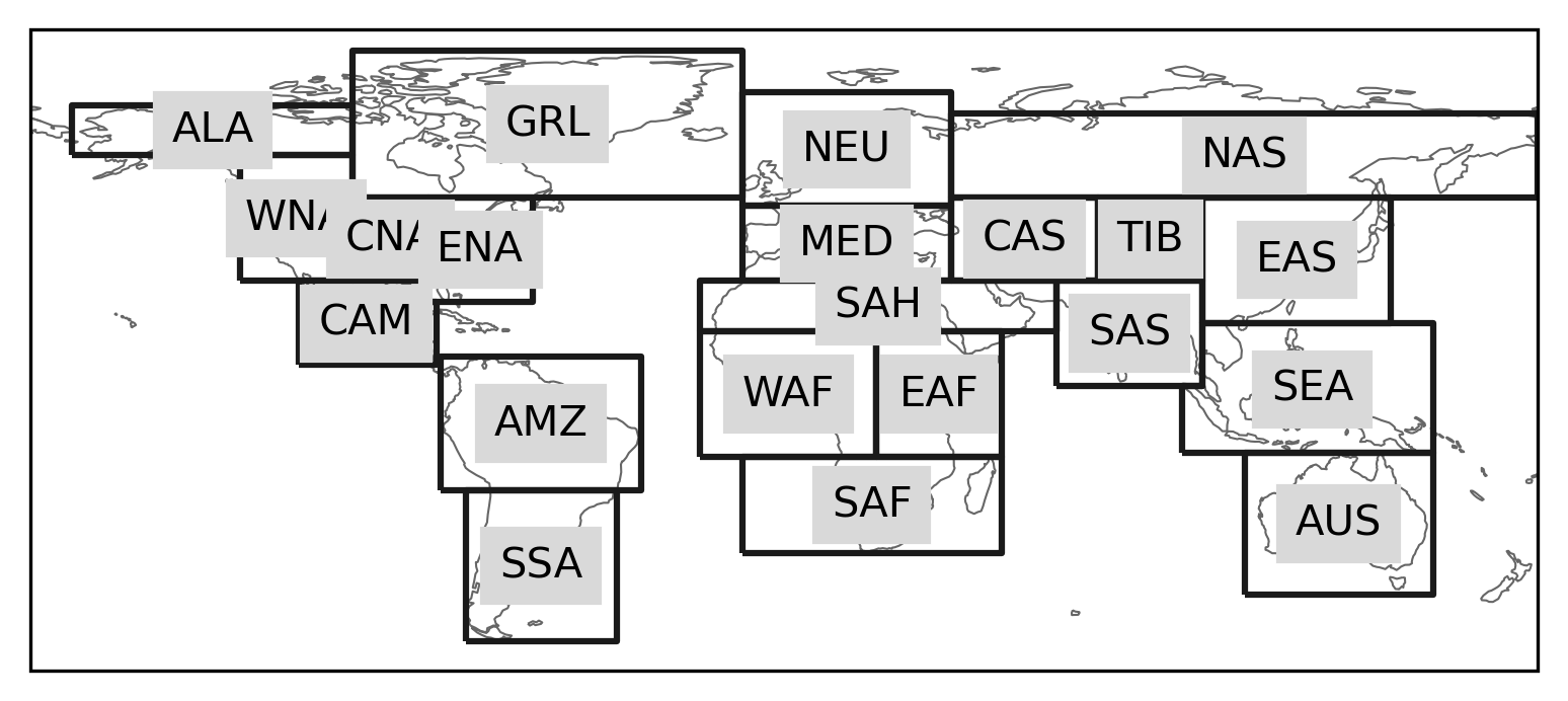
The Giorgi reference regions, rectangular regions proposed in Giorgi and Francisco, 2000 were used in the third and fourth assessment reports of the Intergovernmental Panel on Climate Change (IPCC).
In [3]: regionmask.defined_regions.giorgi
Out[3]:
<regionmask.Regions 'Giorgi'>
Source:   Giorgi and Franciso, 2000 (http://link.springer.com/article/10.1007...
overlap:  False

Regions:
 1 AUS              Australia
 2 AMZ           Amazon Basin
 3 SSA Southern South America
 4 CAM        Central America
 5 WNA  Western North America
..  ..                    ...
17 EAS              East Asia
18 SAS             South Asia
19 CAS           Central Asia
20 TIB                  Tibet
21 NAS             North Asia

[21 regions]
In [4]: regionmask.defined_regions.giorgi.plot(label='abbrev');
SREX Regions
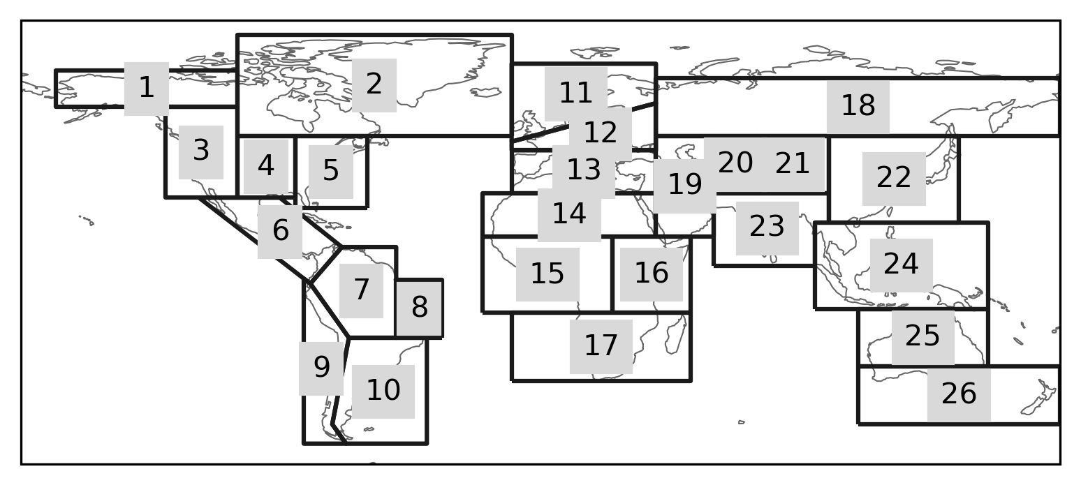
The Giorgi regions were modified using more flexible polygons in the IPCC Special Report on Managing the Risks of Extreme Events and Disasters to Advance Climate Adaptation (SREX; Seneviratne et al., 2012). A slightly modified and extended version of the SREX regions (not included in regionmask) was used for the fifth IPCC assessment report.
In [5]: regionmask.defined_regions.srex
Out[5]:
<regionmask.Regions 'SREX'>
Source:   Seneviratne et al., 2012 (https://www.ipcc.ch/site/assets/uploads/2...
overlap:  False

Regions:
 1 ALA       Alaska/N.W. Canada
 2 CGI     Canada/Greenl./Icel.
 3 WNA         W. North America
 4 CNA         C. North America
 5 ENA         E. North America
..  ..                      ...
22 EAS                  E. Asia
23 SAS                  S. Asia
24 SEA                S.E. Asia
25 NAU             N. Australia
26 SAU S. Australia/New Zealand

[26 regions]
In [6]: regionmask.defined_regions.srex.plot();
AR6 Regions
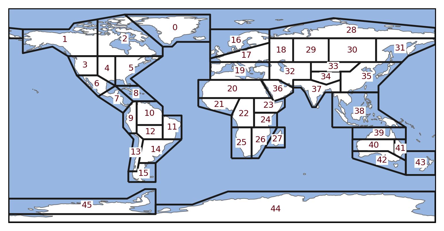
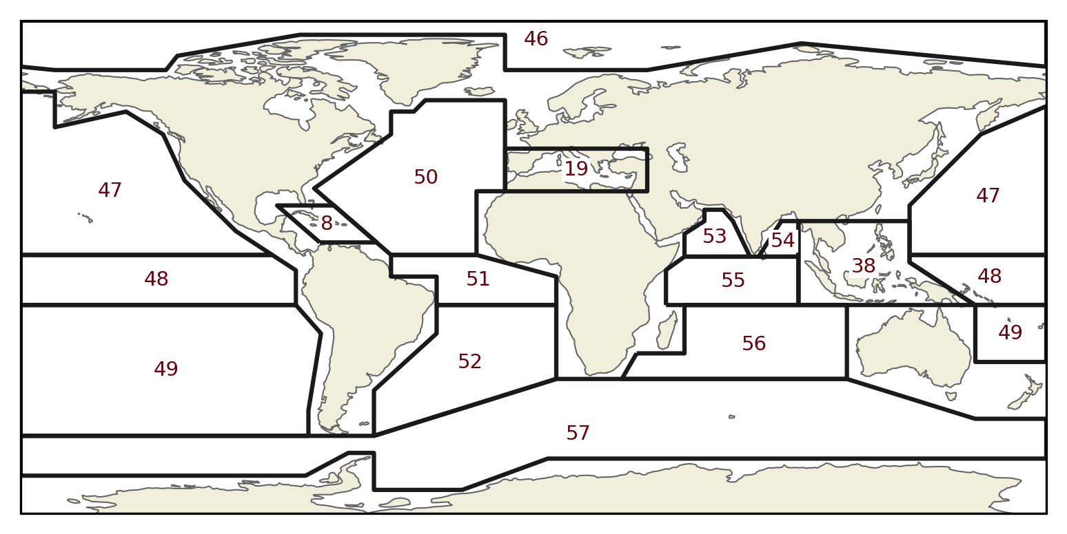
The sixth IPCC assessment report (AR6) again updated the SREX regions in Iturbide et al.,
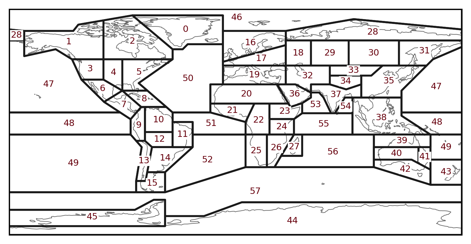
(2020), which defines 58 regions. The regions cover the land and ocean (ar6.all).
In addition the regions are also divided into land (ar6.land) and ocean
(ar6.ocean) categories. The numbering is kept consistent between the categories.
Note that some regions are in the land and in the ocean categories (e.g. the Mediterranean).
All
In [7]: regionmask.defined_regions.ar6.all
Out[7]:
<regionmask.Regions 'AR6 reference regions'>
Source:   Iturbide et al., 2020 (ESSD)
overlap:  False

Regions:
 0 GIC      Greenland/Iceland
 1 NWN      N.W.North-America
 2 NEN      N.E.North-America
 3 WNA        W.North-America
 4 CNA        C.North-America
..  ..                    ...
53 ARS            Arabian-Sea
54 BOB          Bay-of-Bengal
55 EIO Equatorial.Indic-Ocean
56 SIO          S.Indic-Ocean
57 SOO         Southern-Ocean

[58 regions]
In [8]: text_kws = dict(color="#67000d", fontsize=7, bbox=dict(pad=0.2, color="w"))

In [9]: regionmask.defined_regions.ar6.all.plot(
   ...:     text_kws=text_kws, label_multipolygon="all"
   ...: );
   ...:
Land
In [10]: regionmask.defined_regions.ar6.land
Out[10]:
<regionmask.Regions 'AR6 reference regions (land only)'>
Source:   Iturbide et al., 2020 (ESSD)
overlap:  False

Regions:
 0 GIC Greenland/Iceland
 1 NWN N.W.North-America
 2 NEN N.E.North-America
 3 WNA   W.North-America
 4 CNA   C.North-America
..  ..               ...
41 EAU       E.Australia
42 SAU       S.Australia
43  NZ       New-Zealand
44 EAN      E.Antarctica
45 WAN      W.Antarctica

[46 regions]
In [11]: regionmask.defined_regions.ar6.land.plot(text_kws=text_kws, add_ocean=True);
Ocean
In [12]: regionmask.defined_regions.ar6.ocean
Out[12]:
<regionmask.Regions 'AR6 reference regions (ocean only)'>
Source:   Iturbide et al., 2020 (ESSD)
overlap:  False

Regions:
 8 CAR              Caribbean
19 MED          Mediterranean
38 SEA               S.E.Asia
46 ARO           Arctic-Ocean
47 NPO        N.Pacific-Ocean
..  ..                    ...
53 ARS            Arabian-Sea
54 BOB          Bay-of-Bengal
55 EIO Equatorial.Indic-Ocean
56 SIO          S.Indic-Ocean
57 SOO         Southern-Ocean

[15 regions]
In [13]: regionmask.defined_regions.ar6.ocean.plot(
   ....:     text_kws=text_kws, add_land=True, label_multipolygon="all"
   ....: )
   ....:
Out[13]: <GeoAxes: >
PRUDENCE Regions
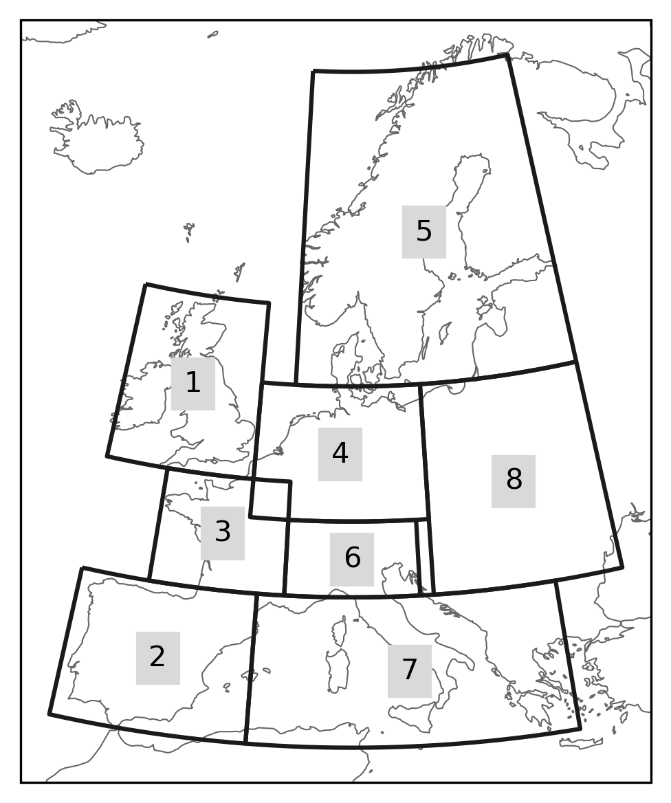
The PRUDENCE regions were defined in the PRUDENCE project as European sub-areas for regional climate model output and are often used in European climate studies. They contain 8 regions, Alps (AL), British Isles (BI), Eastern Europe (EA), France (FR), Iberian Peninsula (IP), Mediterranean (MD), Mid-Europe (ME), and Scandinavia (SC).
Warning
The region FR and ME overlap, hence it is not possible to create 2D masks use prudence.mask_3D(lon, lat).
In [14]: regionmask.defined_regions.prudence
Out[14]:
<regionmask.Regions 'PRUDENCE'>
Source:   Christensen and Christensen, 2007, Climatic Change 81:7-30 (https:/...
overlap:  True

Regions:
1 BI     British Isles
2 IP Iberian Peninsula
3 FR            France
4 ME        Mid-Europe
5 SC       Scandinavia
6 AL              Alps
7 MD     Mediterranean
8 EA    Eastern Europe

[8 regions]
# choose a good projection for regional maps
In [15]: proj = ccrs.LambertConformal(central_longitude=10)

In [16]: regionmask.defined_regions.prudence.plot(projection=proj, resolution="50m");
