Marine Areas/ Ocean Basins (NaturalEarth)
The outline of the marine areas are obtained from Natural Earth. They are automatically downloaded, cached and opened with geopandas. The following marine regions are defined in regionmask:
Marine Areas 1:50m
Warning
regionmask.defined_regions.natural_earth is deprecated.
Please use natural_earth_v4_1_0 or natural_earth_v5_0_0 instead.
Be careful when working with the different versions of NaturalEarth regions. Some polygons and regions have changed and the numbering of the regions may be different.
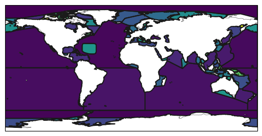
Import regionmask:
In [1]: import regionmask
Ocean Basins
In [2]: basins = regionmask.defined_regions.natural_earth_v5_0_0.ocean_basins_50

In [3]: basins
Out[3]:
<regionmask.Regions>
Name:     Natural Earth: ocean basins 50m
Source:   http://www.naturalearthdata.com
overlap:  False

Regions:
  0            Arctic Ocean            Arctic Ocean
  1          SOUTHERN OCEAN          SOUTHERN OCEAN
  2    North Atlantic Ocean    North Atlantic Ocean
  3     North Pacific Ocean     North Pacific Ocean
  4     South Pacific Ocean     South Pacific Ocean
 ..                     ...                     ...
112 Viscount Melville Sound Viscount Melville Sound
113              Ungava Bay              Ungava Bay
114            Amazon River            Amazon River
115           Yangtze River           Yangtze River
116          Columbia River          Columbia River

[117 regions]
In [4]: basins.plot(add_label=False);

Also create a mask for a 1° grid globally:
In [5]: import numpy as np

# create a grid
In [6]: lon = np.arange(0.5, 360)

In [7]: lat = np.arange(89.5, -90, -1)

In [8]: mask = basins.mask(lon, lat)

In [9]: basins.plot(add_label=False);

In [10]: mask.plot(add_colorbar=False);